N
RELEVANT MATERIAL ISSUE/S
- Managing the environmental impact of our operations and conserving natural resources
RELEVANT IDENTIFIED RISKS
- Licence to operate
The success of our business is ultimately dependent on bringing our mineral resources under management to account safely, efficiently and profitably, while serving as a responsible steward of those natural resources.
Mining activities have an impact on the natural environment: land is disturbed, water is consumed and its quality potentially affected and dust is generated in the air as well as greenhouse gas emissions as a result of the consumption of fossil-based power.
The application and management of water and power are arguably the most strategic of Northam’s natural inputs, given the nature and depth of mining operations at the metallurgical processing infrastructure at Zondereinde. Booysendal is a more modern, mechanised operation and its environmental footprint was a critical feature even in its design.
Northam minimises its impact on the environment and mitigates the environmental risks of our mining and processing activities by having in place policies and procedures which are strictly followed. We seek to comply with all environmental legislation.
MINERAL RESOURCE AND RESERVE STATEMENT
Resources and reserves reflected in this statement are reported on a Northam attributable basis, and include those which are either from properties that are wholly owned by Northam or its wholly-owned subsidiaries, or joint venture properties in which Northam or its subsidiaries hold a stake.
Mineral resources are reported inclusive of mineral reserves.
SCOPE OF REPORTING
Resources and reserves are reported for the following properties:
ZONDEREINDE
the company’s wholly-owned PGM mine, located in the Thabazimbi area of the Limpopo province and within the northern portion of the western limb of the Bushveld Complex. This includes both the Zondereinde and Middeldrift portions of the property.
BOOYSENDAL
wholly owned by Northam’s wholly-owned subsidiary, Booysendal Platinum Proprietary Limited (Booysendal) and situated in the southern portion of the eastern limb of the Bushveld Complex.
DWAALKOP
located in the northern portion of the eastern limb of the Bushveld Complex, in which Northam holds a 50% stake through its wholly-owned subsidiary Mvelaphanda Resources. Dwaalkop is managed by Lonmin plc (Lonmin).
PANDORA
located in the Brits area of North West province and within the southern portion of the western limb of the Bushveld Complex, in which Northam holds a 7.5% stake. Pandora is managed by Lonmin.
KEY POINTS AND SIGNIFICANT REVISIONS FROM LAST YEAR
- The UG2 and Merensky reserves within the Booysendal North and South mines increased following amendments to the underground pillar design.
- There has been a reallocation of Merensky resources from Booysendal North to Booysendal North mine.
- During the 2017 financial year, Northam entered into agreements with Rustenburg Platinum Mines Limited and Glencore Operations South Africa Proprietary Limited regarding the purchase of a portion of the Amandelbult mine and the Eland mine respectively. These purchases are still subject to regulatory approval and therefore are not concluded. Consequently no formal resource or reserve estimates for these properties have been included in this statement. Indicative estimates of resource content within these properties were summarised in Northam’s interim results presentation for the period ending 31 December 2016. This presentation is available on the company’s website at www.northam.co.za
- Mineral resources are reported inclusive of mineral reserves.
- Northam has entered into an agreement to dispose of its participatory interest in the Pandora joint venture to Lonmin’s Eastern Platinum Limited. This transaction is subject to regulatory approval before transaction closure following which the resource and reserve estimates attributable to Northam will be removed from this statement.
REGULATORY COMPLIANCE
The mineral resource and mineral reserve statements for Northam have been prepared under the guidance of the company’s lead competent persons who are duly registered with The Engineering Council of South Africa (ECSA; Private Bag X691, Bruma, 2026, South Africa; www.ecsa.co.za) and/or with the South African Council for Natural Scientific Professions (SACNASP; Private Bag X540, Silverton, 0127, South Africa; www.sacnasp.org.za). This ensures that the mineral resource and mineral reserve statements comply with the provisions of the South African Code for Reporting of Mineral Resources and Mineral Reserves of 2007, revised in 2016 (SAMREC 2016). The company’s competent persons have taken cognisance of definitions included in the code. The mineral resource and mineral reserve quantities reported here are considered to be fully compliant in all material respects to the requirements of the SAMREC code, together with section 12 of the listing requirements of the JSE. The lead competent persons have given written confirmation of such, together with permission to publish these estimates.
Definitions of the various mineral resource and mineral reserve categories as well as the requirements for reporting of exploration results may be found at www.samcode.co.za.
STATUS OF MINERAL RIGHTS
Resources reflected in this statement include those of the Zondereinde, Booysendal and Everest mines which are wholly owned by Northam or its wholly-owned subsidiaries. In addition, Northam holds a 7.5% stake in the Pandora joint venture and a 50% stake in the Dwaalkop joint venture, both of which are managed by Lonmin, through its subsidiaries, Eastern Platinum Limited and Western Platinum Limited respectively.
Northam holds, either directly or through its subsidiaries, new order mining rights over the Zondereinde, Booysendal and Everest mines. The Everest new order mining right was ceded to Booysendal in October 2015 in terms of Section 11 of the Mineral and Petroleum Resources Development Act, No. 28 of 2002.
The Pandora mine operates under a new order mining right which was converted from an old order right in 2013.
The Dwaalkop joint venture holds a new order prospecting right over the Dwaalkop prospect. This right is subject to a renewal application. An application for a new order mining right was submitted in 2009 and is being processed.
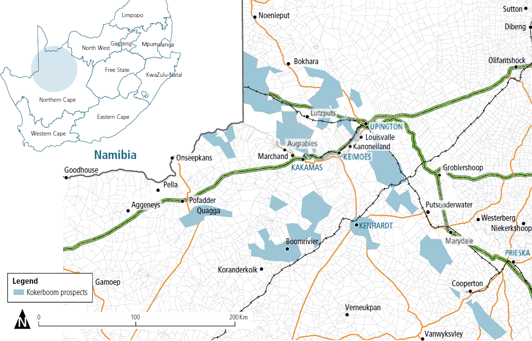
Northam further holds eight new order prospecting rights over the Kokerboom prospect, granted in 2009. Kokerboom is an iron oxide copper gold and massive sulphide copper zinc exploration prospect covering some 1 000 000 hectares of the Northern Cape province of the Republic of South Africa. A prospecting work programme is currently in progress and no resource or reserve has yet been estimated. Exploration at Kokerboom is in its early stages, and only limited exploration costs have been incurred to date. As such, Kokerboom is not material to Northam’s operations.
| Property | Type of right | Status |
|---|---|---|
| Zondereinde mine | New order mining right | Converted mining right |
| Booysendal mine | New order mining right | Converted mining right |
| Everest mine | New order mining right | Converted mining right |
| Pandora mine | New order mining right | Converted mining right |
| Dwaalkop prospect | New order prospecting right | Application for a new order mining right in process |
| Kokerboom prospect | New order prospecting rights | Eight new order prospecting rights granted |
Prospecting and mining rights are held in good order, and Northam perceives no risk to its rights to continue prospecting for and mining of minerals over any of its properties.
CONTINUING OPERATIONS
The company confirms that it is not aware of any legal or arbitration proceedings, either pending or threatened, which may have or have had a material effect on the financial position of the company and its subsidiaries.
Further to this, the risk management section of this report analyses potential risks which may impact the company’s ability to continue its activities.
ENVIRONMENTAL LIABILITIES
The company’s environmental obligations are managed in terms of approved environmental management plans. Compliance with the plans is audited by independent external parties on a regular basis. Details of the environmental liabilities are contained in note 24 to the 2017 annual financial statements and details of the funding of the environmental liabilities are contained in note 12 and note 13 to the 2017 annual financial statements.
GROUP RESOURCES AND RESERVES
The following tables summarise the mineral resources and reserves attributable to Northam for both the current and previous year. Notes on the reporting criteria are pertinent, together with specific notes to this section.
Breakdowns of the mineral resources and reserves into their respective confidence categories may be found in the sections specific to each mining concession.
| as at 30 June 2017 | as at 30 June 2016 | ||||||
|---|---|---|---|---|---|---|---|
| 4E PGE | 4E PGE | ||||||
| Reef | Mine | Mt | g/t | Moz | Mt | g/t | Moz |
| Merensky | Booysendal North | 86.12 | 5.06 | 14.00 | 87.82 | 5.06 | 14.29 |
| Booysendal South | 187.55 | 3.55 | 21.41 | 187.55 | 3.55 | 21.41 | |
| Booysendal North mine | 22.12 | 3.17 | 2.25 | 16.97 | 3.23 | 1.76 | |
| Booysendal South mine | 11.98 | 2.77 | 1.07 | 11.98 | 2.77 | 1.07 | |
| Dwaalkop1 | 38.05 | 2.98 | 3.64 | 38.05 | 2.98 | 3.64 | |
| Pandora1 | 0.00 | 0.00 | 0.00 | 0.00 | 0.00 | 0.00 | |
| Zondereinde | 165.27 | 7.38 | 39.20 | 164.44 | 7.38 | 39.00 | |
| Total | 511.09 | 4.96 | 81.57 | 506.81 | 4.98 | 81.17 | |
| UG2 | Booysendal North | 152.65 | 4.86 | 23.87 | 152.65 | 4.86 | 23.87 |
| Booysendal South | 235.66 | 3.20 | 24.26 | 235.67 | 3.20 | 24.26 | |
| Booysendal North mine | 40.26 | 4.46 | 5.77 | 41.41 | 4.52 | 6.02 | |
| Booysendal South mine | 129.07 | 3.05 | 12.65 | 126.76 | 3.07 | 12.51 | |
| Dwaalkop1 | 37.56 | 4.35 | 5.25 | 37.56 | 4.35 | 5.25 | |
| Pandora1 | 14.18 | 4.65 | 2.12 | 14.14 | 4.65 | 2.11 | |
| Zondereinde | 275.20 | 5.06 | 44.78 | 276.41 | 5.08 | 45.14 | |
| Total | 884.58 | 4.17 | 118.70 | 884.60 | 4.19 | 119.16 | |
| Combined | Booysendal North | 238.77 | 4.93 | 37.87 | 240.47 | 4.94 | 38.16 |
| Booysendal South | 423.22 | 3.36 | 45.67 | 423.22 | 3.36 | 45.67 | |
| Booysendal North mine | 62.38 | 4.00 | 8.02 | 58.38 | 4.15 | 7.78 | |
| Booysendal South mine | 141.05 | 3.02 | 13.72 | 138.74 | 3.04 | 13.58 | |
| Dwaalkop1 | 75.61 | 3.66 | 8.89 | 75.61 | 3.66 | 8.89 | |
| Pandora1 | 14.18 | 4.65 | 2.12 | 14.14 | 4.65 | 2.11 | |
| Zondereinde | 440.47 | 5.93 | 83.98 | 440.85 | 5.94 | 84.14 | |
| Total | 1 395.68 | 4.46 | 200.27 | 1 391.41 | 4.48 | 200.33 | |
1 Current resources and reserves of Pandora and Dwaalkop are quoted as at 30 September 2016 while those of the previous year are at 30 September 2015.
| as at 30 June 2017 | as at 30 June 2016 | ||||||
|---|---|---|---|---|---|---|---|
| 4E PGE | 4E PGE | ||||||
| Reef | Mine | Mt | g/t | Moz | Mt | g/t | Moz |
| Merensky | Booysendal North | 0.00 | 0.00 | 0.00 | 0.00 | 0.00 | 0.00 |
| Booysendal South | 0.00 | 0.00 | 0.00 | 0.00 | 0.00 | 0.00 | |
| Booysendal North mine | 19.34 | 2.87 | 1.78 | 14.51 | 2.92 | 1.36 | |
| Booysendal South mine | 9.84 | 2.58 | 0.82 | 9.36 | 2.58 | 0.78 | |
| Dwaalkop1 | 0.00 | 0.00 | 0.00 | 0.00 | 0.00 | 0.00 | |
| Pandora1 | 0.00 | 0.00 | 0.00 | 0.00 | 0.00 | 0.00 | |
| Zondereinde | 21.86 | 5.53 | 3.89 | 21.01 | 5.51 | 3.72 | |
| Total | 51.04 | 3.95 | 6.49 | 44.88 | 4.06 | 5.86 | |
| UG2 | Booysendal North | 0.00 | 0.00 | 0.00 | 0.00 | 0.00 | 0.00 |
| Booysendal South | 0.00 | 0.00 | 0.00 | 0.00 | 0.00 | 0.00 | |
| Booysendal North mine | 43.84 | 3.00 | 4.23 | 41.53 | 3.00 | 4.00 | |
| Booysendal South mine | 77.57 | 2.64 | 6.58 | 75.86 | 2.65 | 6.48 | |
| Dwaalkop1 | 0.00 | 0.00 | 0.00 | 0.00 | 0.00 | 0.00 | |
| Pandora1 | 1.12 | 4.20 | 0.15 | 1.21 | 4.10 | 0.16 | |
| Zondereinde | 56.84 | 4.14 | 7.56 | 58.64 | 4.24 | 7.99 | |
| Total | 179.37 | 3.21 | 18.52 | 177.24 | 3.27 | 18.63 | |
| Combined | Booysendal North | 0.00 | 0.00 | 0.00 | 0.00 | 0.00 | 0.00 |
| Booysendal South | 0.00 | 0.00 | 0.00 | 0.00 | 0.00 | 0.00 | |
| Booysendal North mine | 63.18 | 2.96 | 6.01 | 56.04 | 2.98 | 5.36 | |
| Booysendal South mine | 87.41 | 2.63 | 7.40 | 85.22 | 2.65 | 7.26 | |
| Dwaalkop1 | 0.00 | 0.00 | 0.00 | 0.00 | 0.00 | 0.00 | |
| Pandora1 | 1.12 | 4.20 | 0.15 | 1.21 | 4.10 | 0.16 | |
| Zondereinde | 78.70 | 4.53 | 11.45 | 79.65 | 4.58 | 11.71 | |
| Total | 230.41 | 3.38 | 25.01 | 222.12 | 3.43 | 24.48 | |
1 Current resources and reserves of Pandora and Dwaalkop are quoted as at 30 September 2016 while those of the previous year are at 30 September 2015.
COMPETENT PERSONS
The resource and reserve statement for the Zondereinde and Middeldrift portions of Zondereinde mine were compiled by Charl van Jaarsveld, BSc (Hons) Geology, PrSciNat. (400268/05); chief geologist at Zondereinde mine, with 14 years’ experience relevant to Bushveld-related resource and reserve estimation.
The Booysendal resource statement was compiled by Meshack Mqadi, BSc (Hons) Geology, PrSciNat. (400703/15); chief geologist at Booysendal North mine, with nine years’ experience relevant to precious metal-related resource estimation.
The Booysendal reserve statement was compiled by Willie Theron, BSc (Hons) Mining, PrCertEng, ECSA (200790030); general manager at Booysendal UG2 North mine with 20 years’ experience of Bushveld-related underground mining and reserve estimation.
Resource and reserve estimates for both Zondereinde and Booysendal were reviewed by Damian Smith, BSc (Hons) Geology, MSc, PrSciNat. (400323/04); principal member of Prospect Geoservices with 27 years’ experience in mining and exploration geology, 22 years of which are relevant to Bushveld-related resource and reserve estimation.
The resource estimates for the Pandora joint venture were compiled by Nicole Wansbury (Lonmin).
The resource and reserve estimates for the Dwaalkop joint venture were prepared by a team from Snowden Mining Industry Consultants (Resources) and from AMC Consulting (Proprietary) Limited (Reserves).
Lonmin Resources and Reserves are signed off by Dennis Hoffmann (Lonmin), while reserves were signed off by Leon Koorsse (Lonmin).
Contact details for Northam’s lead competent persons authorising publication of the resource estimates are contained within the notes on reporting criteria within this report.
GEOLOGICAL SETTING – THE BUSHVELD COMPLEX
The two-billion-year-old Bushveld Complex is the largest layered igneous complex in the world, and is the repository for around 85% of known global PGM resources. Extending over an area of some 67 000km2 within the north-eastern portion of the Republic of South Africa, it contains the intrusive, mafic-ultramafic Rustenburg Layered Suite (RLS), which outcrops as three main acicular limbs, namely the western, eastern and northern limbs (see figure below), and ranges in thickness from 7km to 12km.
The magmatic layering in the RLS is laterally persistent and can be correlated throughout most of the complex. Layering is generally shallow dipping towards the centre of the complex. The RLS stratigraphy is sub-divided into five zones, which are, from lowest to highest, the marginal zone, the lower zone, the critical zone (which is further subdivided into a lower and upper unit), the main zone and the upper zone.
PGM and associated precious and base metal mineralisation is hosted in or adjacent to chromitite seams located within the upper critical zone of the RLS. There are two significant orebodies from which 75% of global primary PGM production is derived, these being the UG2 and Merensky reefs. The vertical separation between the UG2 and Merensky reefs is variable across the Bushveld Complex, ranging from 20m to 140m on the western limb and between 170m and 400m on the eastern limb.
Historically, PGM production was concentrated on the western limb but, in recent years, the eastern limb has been the focus of new mine development.
The two wholly-owned Northam properties, the Zondereinde and Booysendal mines, contain resources of both the UG2 and Merensky reefs.
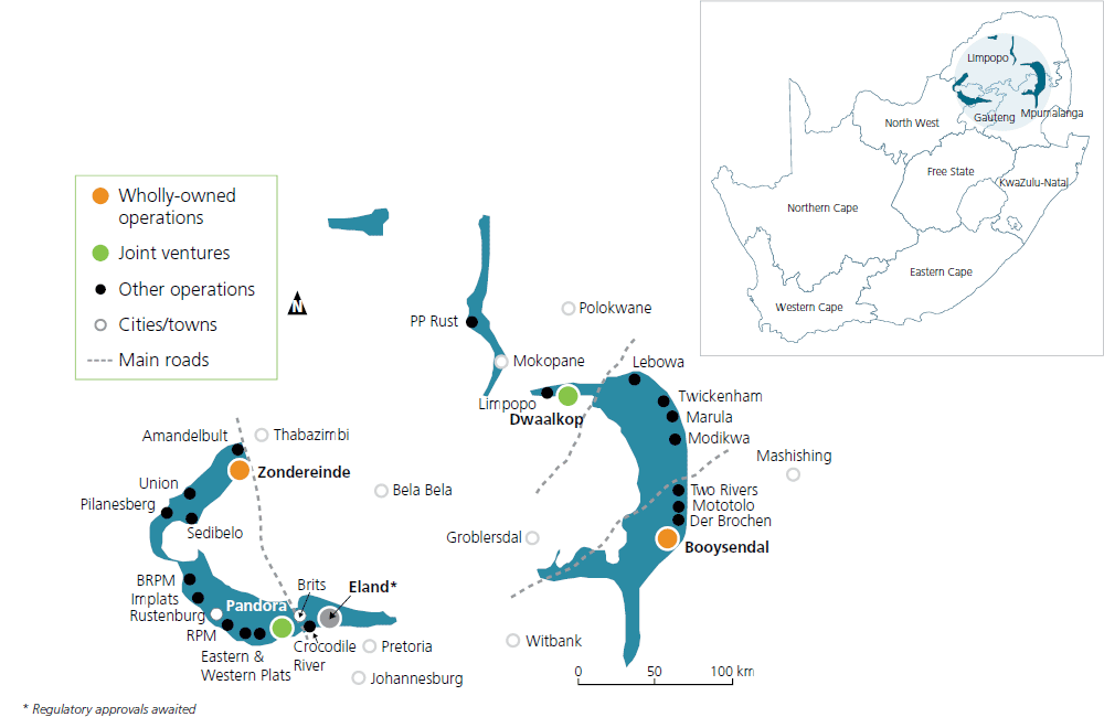
Bushveld location indicating current PGM mining operations
ZONDEREINDE MINE
Zondereinde location and access routes
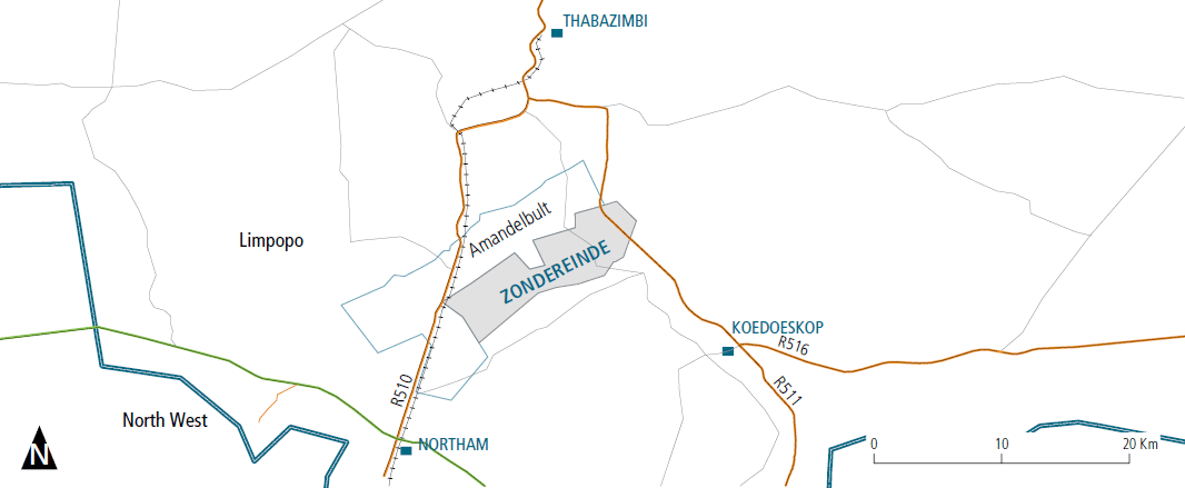
Zondereinde mine is situated in the northern portion of the western limb of the Bushveld Complex, approximately 30km south of the town of Thabazimbi in the Limpopo province of the Republic of South Africa. The mining concession covers some 7 625ha underlain by both the Merensky and UG2 ore bodies, which dip at approximately 20˚ and extend from a depth of 1 100m to 2 900m below surface.
The company exploits both the Merensky and UG2 reefs of the upper critical zone of the Bushveld Complex. While there is lateral continuity of both reefs across the mine property, the Merensky reef displays a variety of reef types. The distribution of these is determined by a combination of surface exploration boreholes, ongoing prospect drilling from underground development and reef mapping in development and stoping. In contrast to the Merensky reef, the UG2 displays little variation in reef attributes.
The Bushveld sequence at Zondereinde is typical of the northern portion of the western limb. The critical zone stratigraphy is telescoped and dominated by mafic lithologies. Vertical separation between the UG2 and Merensky reefs is in the range of 20m to 40m.
Combined geological and extraction losses were discounted from the resources for both reefs. These comprised pothole and structural losses as well as other pillar losses. Discount losses vary per reef type and resource category, but average at 32% for Merensky reef. Discount losses for UG2 average 36% and are largely contained in regional support pillars designed to counter stress concentration resulting from mining in proximity to previously-mined Merensky reef.
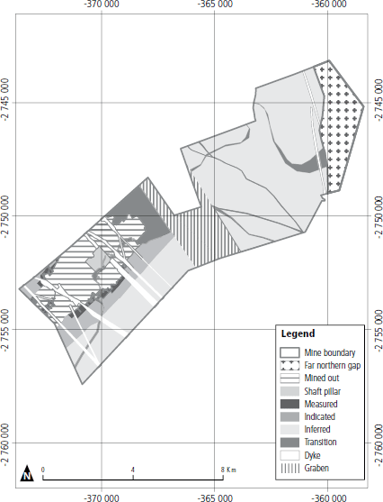
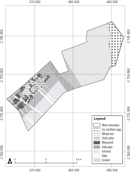
Measured resources are defined in the areas accessible from holed on-reef development within three months of the estimation run and/or bounded by haulage borehole intersections and the nearest stope exposures. Indicated resources are defined in all other areas, down to a depth of 2 350mbc (18 level elevation). This is the depth to which the Zondereinde mine has a feasible mine plan, and is currently in the process of accessing via a deepening extension project.
Inferred resources extend from 18 Level to the down dip mine boundary.
HISTORY AND MINING ACTIVITIES
Development of Zondereinde mine started in 1986, following a five-year exploration programme. Mining of ore, commissioning of a PGM concentrator, smelter and base metal removal plant and the sale of first PGMs came in 1993. The mine originally exploited only the Merensky reef resource but the commissioning of a UG2 concentrator in 2000, together with the necessary underground ore handling systems, allowed mining and processing of UG2 from this time onwards. The mine produces approximately 2 000 000 tonnes of ore per annum, generating in the order of 300 000oz of 3PGE+Au in final concentrate together with associated precious and base metal by-products.
Underground mining focuses on the exploitation of PGM ores by means of traditional narrow tabular reef drill and blast mining methods. A standard breast mining layout is used at Northam. The vertical interval (distance) between levels is 63m. With the orebody dipping at 20°, this provides a raise length of 180m allowing for six panels of 30m each per raise connection. Strike gullies are aligned at 10° above the strike direction. A dip gully handles the ore transported via the strike gullies to three orepasses situated in the original raise, all of which are fitted with radial-door control chutes. Ore is transported to the main shaft ore passes by battery powered locomotives (locos) pulling spans of eight hoppers. Broken ore is transported to a conventional shaft ore-pass system with separate rock handling facilities for Merensky reef, UG2 reef and waste.
Mining is successfully conducted using hydropowered equipment such as rock drills and high-pressure water jets in conjunction with electric scraper winches.
The underground workings are accessed from a twin shaft system. No 1 shaft extends to 13 level (2 039m below surface) and No 2 shaft serves workings down to 8 level (1 724m below surface). The shafts are 90m apart and are interconnected at an intermediate pump chamber (IPC) at 1 019m below surface, and also on levels 2, 4, 6, 7, 8 and 9. Workings below 13 level are serviced by decline access ways, designed to accommodate both people and materials, and equipped with a conveyor belt system that transports the broken rock.
MERENSKY REEF
The Merensky reef is a zone of mineralisation which straddles the base of the Merensky cyclic unit. In the area of Zondereinde mine, the Merensky reef consists of two sub-facies of the Zwartklip facies of the RLS, namely the normal and regional pothole sub-facies. The latter may be further subdivided into three reef types, each of which occurs at a specific stratigraphic level below that of the normal reef sub-facies. These being NP2 and P2, which constitute the main sources of ore, and FWP2 which, while not considered a primary mining target due to the undulating nature of this reef type, is successfully exploited in the south- western quadrant of the current mining area where it displays lesser disruption.
The stoping cut on the Merensky reef is dependent upon the reef type mined and the geozone in which it is located. In all stoping cuts, the Merensky chromitite is exposed with a minimum of 10cm of the overlying mineralised Merensky pyroxenite as hanging wall.
The Merensky measured resource has increased from 3.26Mt (0.80Moz) in June 2016 to 3.56Mt (0.87Moz) in June 2017. This is the result of an increase in the exposed Merensky resource.
The Merensky indicated resource has increased as a result of a positive reinterpretation of the western limit of the Merensky Normal facies extent below 15 level. The Merensky inferred resource is essentially unchanged.
UG2 REEF
The UG2 reef at Zondereinde mine is remarkably conformable when compared with the Merensky reef. Disruption, in the form of potholes and reef rolls, is extremely limited and localised. The reef consists of three chromitite seams separated by narrow pyroxenite partings. The lower seam, termed the main member, is generally in the order of 85cm thick, and is overlain by two leader seams, each in the order of 15cm thick. Total reef thickness, inclusive of a portion of mineralised reef footwall, is in the order of 150cm to 160cm. There is no basis for subdividing the UG2 reef into facies types.
Historically, UG2 mining has been limited to de-stressed areas underlying previously mined Merensky reef. Furthermore, a full reef cut is mined, which enhances metal output, hanging wall stability and safe working practices.
The UG2 measured resource has increased from 9.60Mt (1.56Moz) in June 2016 to 10.55Mt (1.69Moz) in June 2017. This is the result of both an increase in the exposed UG2 resource and improved mining extraction experienced as UG2 mining continues to move into areas where there is less influence of Merensky abutments. The UG2 indicated resource decreased as a result of conversion to the measured category. The UG2 inferred resource is essentially unchanged.
Zondereinde resources and reserves
Zondereinde Merensky resource classification 2017
Zondereinde UG2 resource classification 2017
| as at 30 June 2017 | as at 30 June 2016 | ||||||
|---|---|---|---|---|---|---|---|
| 4E PGE | 4E PGE | ||||||
| Reef | Category | Mt | g/t | Moz | Mt | g/t | Moz |
| Merensky | Measured | 3.56 | 7.61 | 0.87 | 3.26 | 7.70 | 0.80 |
| Indicated | 15.11 | 7.07 | 3.43 | 14.59 | 7.16 | 3.36 | |
| Inferred | 146.60 | 7.39 | 34.90 | 146.59 | 7.39 | 34.84 | |
| Total | 165.27 | 7.38 | 39.20 | 164.44 | 7.38 | 39.00 | |
| UG2 | Measured | 10.55 | 4.99 | 1.69 | 9.60 | 5.04 | 1.56 |
| Indicated | 44.88 | 4.99 | 7.19 | 47.04 | 5.04 | 7.62 | |
| Inferred | 219.77 | 5.08 | 35.90 | 219.77 | 5.09 | 35.96 | |
| Total | 275.20 | 5.06 | 44.78 | 276.41 | 5.08 | 45.14 | |
| Combined | Measured | 14.11 | 5.65 | 2.56 | 12.86 | 5.72 | 2.36 |
| Indicated | 59.99 | 5.51 | 10.62 | 61.63 | 5.54 | 10.98 | |
| Inferred | 366.37 | 6.00 | 70.80 | 366.36 | 6.01 | 70.80 | |
| Total | 440.47 | 5.93 | 83.98 | 440.85 | 5.94 | 84.14 | |
| as at 30 June 2017 | as at 30 June 2016 | ||||||
|---|---|---|---|---|---|---|---|
| 4E PGE | 4E PGE | ||||||
| Reef | Category | Mt | g/t | Moz | Mt | g/t | Moz |
| Merensky | Proven | 4.31 | 5.77 | 0.80 | 3.97 | 5.78 | 0.73 |
| Probable | 17.55 | 5.44 | 3.09 | 17.04 | 5.45 | 2.99 | |
| Total | 21.86 | 5.53 | 3.89 | 21.01 | 5.51 | 3.72 | |
| UG2 | Proven | 11.00 | 4.14 | 1.46 | 10.10 | 4.24 | 1.38 |
| Probable | 45.84 | 4.14 | 6.10 | 48.53 | 4.24 | 6.61 | |
| Total | 56.84 | 4.14 | 7.56 | 58.64 | 4.24 | 7.99 | |
| Combined | Proven | 15.31 | 4.60 | 2.26 | 14.07 | 4.67 | 2.11 |
| Probable | 63.39 | 4.50 | 9.19 | 65.58 | 4.55 | 9.61 | |
| Total | 78.70 | 4.53 | 11.45 | 79.65 | 4.58 | 11.72 | |
| Prill splits % | Pt | Pd | Rh | Au | Cr2O3% | Cu% | Ni% |
| UG2 | 57.7 | 30.9 | 10.3 | 1.0 | 27.6 | 0.021 | 0.123 |
| Merensky | 63.0 | 29.2 | 5.2 | 2.6 | 0.80 | 0.072 | 0.164 |
BOOYSENDAL MINE
Booysendal location and access routes
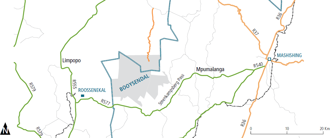
The Booysendal mining concession is located in the southern compartment of the eastern limb of the Bushveld Complex, approximately 35km west of the town of Mashishing (formerly Lydenburg), straddling the border of Limpopo and Mpumalanga provinces in the Republic of South Africa.
The concession covers some 17 979 hectares and hosts both the UG2 and Merensky orebodies, which outcrop over a strike length of 14.5km and dip at approximately 10˚ to the west.
The resource estimate is informed by exploration data, including 614 boreholes, together with 2 460 UG2 channel samples from on-reef development and stoping within the UG2 and Merensky sections of the Booysendal North mine, together with the Everest UG2 mine. A further 199 channel samples from on- reef development and stoping within the Merensky section of the Booysendal North mine have been analysed. 90% of the exploration drilling has been conducted within 2.5km down-dip of outcrop. Drill hole spacing in this near outcrop area ranges from 150m to 350m. Channel samples are located at 15m intervals within on-reef development and stoping.
A study to determine the feasibility of mining UG2 reef within the northernmost 8km of the Booysendal strike, over a dip extent from outcrop of approximately 2km, was completed in September 2009. Development of a UG2 mine (UG2 section of the Booysendal North mine) in the northernmost 4km of strike started in May 2010 and reached its steady state production rate of 187 000 tonnes per month in October 2015. A mine expansion programme was initiated during the latter part of 2015. This will grow production to 210 000 tonnes per month from October 2018.
A study to determine the feasibility of mining Merensky reef over a similar footprint to the UG2 section of the Booysendal North mine was completed in December 2015. Development of the Phase 1 Merensky section of the Booysendal North mine commenced immediately following this. Steady state production of 23 000 tonnes per month was achieved in August 2016. A Phase 2 extension is planned which would grow production up to 75 000 tonnes per month.
A study to determine the feasibility of mining both UG2 and Merensky reef from four mining modules in the central and southern portions of Booysendal was completed in June 2016. Development of three modules has commenced and they are expected to reach a steady state production rate in June 2021.
The resource estimate for the Booysendal concession is subdivided into four sections, these being; the combined UG2 and Merensky North mines (North mine); the remainder of the northern section of the concession (Booysendal North); combined UG2 and Merensky South mines (South mine); and the remainder of the southern section (Booysendal South); Mineral reserve estimates are presented for the North and South mines.
The Bushveld sequence at Booysendal is similar to that found across the southern compartment of the eastern limb. The critical zone stratigraphy is fully developed, and middling between the UG2 and Merensky reefs is in the order of 175m in the northern and central portions of Booysendal. The sequence is, however, subject to thinning in the far southern portion, which is linked to the Bushveld rocks abutting basement highs. The impact of this ‘abutment’ is further manifested in localised zones of disruption to surface morphology and internal structure of the two reefs. This has led to the characterisation of three geozones within the Booysendal concession, these being the normal, slump and abutment geozones. Despite this progressive disruption to the south, the continuity of the reef surfaces is robust across the property.
The internal structure of the UG2 reef is similar to that found on the Bushveld western limb, while the Merensky reef is typical of the northern portion of the Bushveld eastern limb.
The UG2 reef consists of an upper leader chromitite and a lower main chromitite with a combined thickness of some 140cm. These seams are generally juxtaposed or merged, but can display variable internal silicate partings.
The Merensky reef is the upper mineralised portion of the Merensky pyroxenite, generally extending over 110cm. The Merensky reef is immediately overlain by a sequence of competent norites.
Resources were estimated over the mineable reef channels. For the UG2 reef, the reef channel extends from the top of the leader chromitite to the base of the main chromitite seam. For the Merensky reef outside of the North Mine area, the reef channel extends from the top of the Merensky pyroxenite to a sample grade cut off of 1g/t, with a minimum mining channel width of 80cm applied. The Merensky reef channel of the Booysendal North and South mines is 210cm in thickness, extending from 20cm above the top of the Merensky Pyroxenite – this is the envisaged mining channel.
Geological losses were discounted from the resources for both reefs. These, for the Booysendal North and South sections, comprised known pothole and structural losses, together with assumed pothole losses benchmarked to mean eastern limb losses. They amounted to 23% for the Merensky reef and 24% and 30% for the UG2 in the North and South sections respectively. In the UG2 mining sections, ongoing mining and exploration drilling has improved confidence in known geological losses, leading to the application of 12.5% total geological loss for the UG2 reef of North mine and 15.0% total geological loss for the UG2 reef of South mine. Furthermore, a channel cut-off 4E grade of 2.5g/t was applied to estimated blocks in all three sections. In addition, a 30m thick surface oxidised zone was discounted along the lines of outcrop of both reefs.
Resource categorisation was based upon a combination of quantitative geostatistical parameters, together with a qualitative appreciation of orebody continuity informed by the resource database together with data from surrounding properties.
MINE DESIGN AND MINING ACTIVITIES
The UG2 sections of Booysendal North and South mines are underground, mechanised bord and pillar mines, accessed from surface via ramp decline systems. The North mine decline system comprises three declines on the plane of reef and one decline situated 20m into the footwall of the reef, containing a belt for ore handling. Decline systems for the South UG2 mines comprise four declines on the plane of reef.
Mining sections extend over a dip length of 144m, equating to a vertical interval of 25m. Strike drives are inclined at 5° above the line of strike, Strike belts within the drives transport ore to the central decline dip belt system for transport to a UG2 concentrator plant on surface. Mechanised boom rigs and LHDs are employed in mining and development.
North UG2 mine is planned, with a remaining life of 19 years, to produce 2 400 000 tonnes of ore per annum at steady state, generating in the order of 190 000oz of metals in concentrate (4E), together with associated precious and base metal by-products.
The initial two modules of South mine have estimated lives of greater than 20 years at a combined steady state production rate of 2 640 000 tonnes of ore per year, generating 215 000oz of metals in concentrate (4E), together with associated precious and base metal by-products.
The North Merensky mine is essentially an analog of the UG2 South mines with all development on reef. Dependent upon prevailing market conditions, the phase 1 mine is planned to produce at 250 000 tonnes of ore per annum at steady state, generating in the order of 25 000oz of metals in concentrate (4E), together with associated precious and base metal by-products.
BOOYSENDAL RESOURCES AND RESERVES
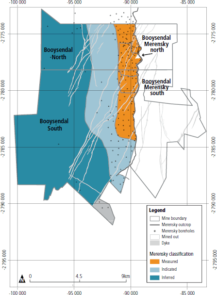
Booysendal Merensky resource classification 2017
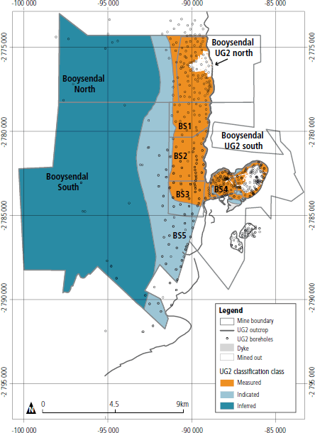
Booysendal UG2 resource classification 2017
NORTH MINE
UG2 reef
The UG2 measured resource for the Booysendal North mine has decreased from 41.41Mt (6.02Moz) in June 2016 to 40.26Mt (5.77Moz) in June 2017 as a result of mining depletion.
The UG2 proven reserve increased from 41.53Mt (4.00Moz) in June 2016 to 43.84Mt (4.23Moz) in June 2017 as a result of a reduction in mining pillar loss following a redesign process undertaken during this reporting period.
Merensky reef
The Merensky measured resource for the Booysendal North mine has increased from 16.97Mt (1.76Moz) in June 2016 to 22.12Mt (2.25Moz) in June 2017, as a result of an amendment to the mine boundary, thus reallocating resources from Booysendal North.
The Merensky proven reserve has increased from 14.51Mt (1.36Moz) in June 2016 to 19.34Mt (1.78Moz) in June 2017, as a combined result of the increased resource base and a reduction in mining pillar loss following a redesign process undertaken during this reporting period.
| as at 30 June 2017 | as at 30 June 2016 | ||||||
|---|---|---|---|---|---|---|---|
| 4E PGE | 4E PGE | ||||||
| Reef | Category | Mt | g/t | Moz | Mt | g/t | Moz |
| Merensky | Measured | 22.12 | 3.17 | 2.25 | 16.97 | 3.23 | 1.76 |
| Indicated | 0.00 | 0.00 | 0.00 | 0.00 | 0.00 | 0.00 | |
| Inferred | 0.00 | 0.00 | 0.00 | 0.00 | 0.00 | 0.00 | |
| Total | 22.12 | 3.17 | 2.25 | 16.97 | 3.23 | 1.76 | |
| UG2 | Measured | 40.26 | 4.46 | 5.77 | 41.41 | 4.52 | 6.02 |
| Indicated | 0.00 | 0.00 | 0.00 | 0.00 | 0.00 | 0.00 | |
| Inferred | 0.00 | 0.00 | 0.00 | 0.00 | 0.00 | 0.00 | |
| Total | 40.26 | 4.46 | 5.77 | 41.41 | 4.52 | 6.02 | |
| Combined | Measured | 62.38 | 4.00 | 8.02 | 58.38 | 4.15 | 7.78 |
| Indicated | 0.00 | 0.00 | 0.00 | 0.00 | 0.00 | 0.00 | |
| Inferred | 0.00 | 0.00 | 0.00 | 0.00 | 0.00 | 0.00 | |
| Total | 62.38 | 4.00 | 8.02 | 58.38 | 4.15 | 7.78 | |
| as at 30 June 2017 | as at 30 June 2016 | ||||||
|---|---|---|---|---|---|---|---|
| 4E PGE | 4E PGE | ||||||
| Reef | Category | Mt | g/t | Moz | Mt | g/t | Moz |
| Merensky | Proven | 19.34 | 2.87 | 1.78 | 14.51 | 2.92 | 1.36 |
| Probable | 0.00 | 0.00 | 0.00 | 0.00 | 0.00 | 0.00 | |
| Total | 19.34 | 2.87 | 1.78 | 14.51 | 2.92 | 1.36 | |
| UG2 | Proven | 43.84 | 3.00 | 4.23 | 41.53 | 3.00 | 4.00 |
| Probable | 0.00 | 0.00 | 0.00 | 0.00 | 0.00 | 0.00 | |
| Total | 43.84 | 3.00 | 4.23 | 41.53 | 3.00 | 4.00 | |
| Combined | Proven | 63.18 | 2.96 | 6.01 | 56.04 | 2.98 | 5.36 |
| Probable | 0.00 | 0.00 | 0.00 | 0.00 | 0.00 | 0.00 | |
| Total | 63.18 | 2.96 | 6.01 | 56.04 | 2.98 | 5.36 | |
| Prill splits % | Pt | Pd | Rh | Au | Cr2O3% | Cu% | Ni% |
| UG2 | 57.2 | 32.6 | 9.4 | 0.8 | 25.1 | 0.008 | 0.087 |
| Merensky | 58.0 | 30.9 | 2.5 | 8.8 | 0.2 | 0.095 | 0.204 |
SOUTH MINE
UG2 reef
The UG2 measured resource for the Booysendal South mine has increased marginally from 126.76Mt (12.51Moz) in June 2016 to 129.07Mt (12.65Moz) in June 2017 as a result of amendment to the resource channel cut based on experience garnered from mining at Booysendal North mine.
The UG2 proven reserve has increased, in line with the measured resource, from 68.24Mt (5.84Moz) in June 2016 to 69.95Mt (5.94Moz) in June 2017.
Merensky reef
The measured resource for the single Merensky module of Booysendal South mine, at 11.98Mt (1.07Moz), is unchanged from the previous reporting period.
The Merensky proven reserve has increased from 9.36Mt (0.78Moz) in June 2016 to 9.84Mt (0.82Moz) in June 2017, as a result of a reduction in mining pillar loss following a redesign process undertaken during this reporting period.
| as at 30 June 2017 | as at 30 June 2016 | ||||||
|---|---|---|---|---|---|---|---|
| 4E PGE | 4E PGE | ||||||
| Reef | Category | Mt | g/t | Moz | Mt | g/t | Moz |
| Merensky | Measured | 11.98 | 2.77 | 1.07 | 11.98 | 2.77 | 1.07 |
| Indicated | 0.00 | 0.00 | 0.00 | 0.00 | 0.00 | 0.00 | |
| Inferred | 0.00 | 0.00 | 0.00 | 0.00 | 0.00 | 0.00 | |
| Total | 11.98 | 2.77 | 1.07 | 11.98 | 2.77 | 1.07 | |
| UG2 | Measured | 107.75 | 3.01 | 10.42 | 105.10 | 3.03 | 10.24 |
| Indicated | 20.20 | 3.24 | 2.10 | 20.53 | 3.24 | 2.14 | |
| Inferred | 1.12 | 3.53 | 0.13 | 1.13 | 3.53 | 0.13 | |
| Total | 129.07 | 3.05 | 12.65 | 126.76 | 3.07 | 12.51 | |
| Combined | Measured | 119.73 | 2.98 | 11.49 | 117.08 | 3.00 | 11.31 |
| Indicated | 20.20 | 3.24 | 2.10 | 20.53 | 3.24 | 2.14 | |
| Inferred | 1.12 | 3.53 | 0.13 | 1.13 | 3.53 | 0.13 | |
| Total | 141.05 | 3.02 | 13.72 | 138.74 | 3.04 | 13.58 | |
| as at 30 June 2017 | as at 30 June 2016 | ||||||
|---|---|---|---|---|---|---|---|
| 4E PGE | 4E PGE | ||||||
| Reef | Category | Mt | g/t | Moz | Mt | g/t | Moz |
| Merensky | Proven | 9.84 | 2.58 | 0.82 | 9.36 | 2.58 | 0.78 |
| Probable | 0.00 | 0.00 | 0.00 | 0.00 | 0.00 | 0.00 | |
| Total | 9.84 | 2.58 | 0.82 | 9.36 | 2.58 | 0.78 | |
| UG2 | Proven | 69.95 | 2.64 | 5.94 | 68.24 | 2.66 | 5.84 |
| Probable | 7.62 | 2.61 | 0.64 | 7.62 | 2.61 | 0.64 | |
| Total | 77.57 | 2.64 | 6.58 | 75.86 | 2.65 | 6.48 | |
| Combined | Proven | 79.79 | 2.63 | 6.76 | 77.60 | 2.65 | 6.61 |
| Probable | 7.62 | 2.61 | 0.64 | 7.62 | 2.61 | 0.64 | |
| Total | 87.41 | 2.63 | 7.40 | 85.22 | 2.65 | 7.26 | |
| Prill splits % | Pt | Pd | Rh | Au | Cr2O3% | Cu% | Ni% |
| UG2 | 60.1 | 29.2 | 9.6 | 1.0 | 19.3 | 0.009 | 0.076 |
| Merensky | 57.9 | 30.9 | 2.3 | 8.9 | 0.1 | 0.083 | 0.186 |
BOOYSENDAL NORTH AND SOUTH
The Merensky measured resource for Booysendal North has decreased from 9.90Mt (1.71Moz) in June 2016 to 8.20Mt (1.42Moz) in June 2017, as a result of an amendment to the Booysendal North mine boundary, thus reallocating resources from Booysendal North.
All categories of the UG2 resource for Booysendal North and of the Merensky and UG2 resources for Booysendal South are unchanged from the previous reporting period.
| as at 30 June 2017 | as at 30 June 2016 | ||||||
|---|---|---|---|---|---|---|---|
| 4E PGE | 4E PGE | ||||||
| Reef | Category | Mt | g/t | Moz | Mt | g/t | Moz |
| Merensky | Measured | 8.20 | 5.36 | 1.42 | 9.90 | 5.36 | 1.71 |
| Indicated | 25.32 | 5.12 | 4.17 | 25.32 | 5.12 | 4.17 | |
| Inferred | 52.60 | 4.97 | 8.41 | 52.60 | 4.97 | 8.41 | |
| Total | 86.12 | 5.06 | 14.00 | 87.82 | 5.06 | 14.29 | |
| UG2 | Measured | 7.05 | 4.95 | 1.12 | 7.05 | 4.95 | 1.12 |
| Indicated | 12.95 | 5.15 | 2.15 | 12.95 | 5.15 | 2.15 | |
| Inferred | 132.65 | 4.83 | 20.60 | 132.65 | 4.83 | 20.60 | |
| Total | 152.65 | 4.86 | 23.87 | 152.65 | 4.86 | 23.87 | |
| Combined | Measured | 15.25 | 5.17 | 2.54 | 16.95 | 5.19 | 2.83 |
| Indicated | 38.27 | 5.13 | 6.32 | 38.27 | 5.13 | 6.32 | |
| Inferred | 185.25 | 4.87 | 29.01 | 185.25 | 4.87 | 29.02 | |
| Total | 238.77 | 4.93 | 37.87 | 240.47 | 4.94 | 38.16 | |
| Prill splits % | Pt | Pd | Rh | Au | Cr2O3% | Cu% | Ni% |
| UG2 | 56.8 | 33.8 | 8.6 | 0.7 | 25.8 | 0.006 | 0.085 |
| Merensky | 59.7 | 30.5 | 2.2 | 7.6 | 0.17 | 0.134 | 0.292 |
| as at 30 June 2017 | as at 30 June 2016 | ||||||
|---|---|---|---|---|---|---|---|
| 4E PGE | 4E PGE | ||||||
| Reef | Category | Mt | g/t | Moz | Mt | g/t | Moz |
| Merensky | Measured | 15.92 | 2.94 | 1.51 | 15.92 | 2.94 | 1.51 |
| Indicated | 51.95 | 3.31 | 5.53 | 51.94 | 3.31 | 5.53 | |
| Inferred | 119.68 | 3.74 | 14.37 | 119.69 | 3.74 | 14.37 | |
| Total | 187.55 | 3.55 | 21.41 | 187.55 | 3.55 | 21.41 | |
| UG2 | Measured | 0.00 | 0.00 | 0.00 | 0.00 | 0.00 | 0.00 |
| Indicated | 85.08 | 3.58 | 9.80 | 85.08 | 3.58 | 9.80 | |
| Inferred | 150.58 | 2.99 | 14.46 | 150.59 | 2.99 | 14.46 | |
| Total | 235.66 | 3.20 | 24.26 | 235.67 | 3.20 | 24.26 | |
| Combined | Measured | 15.92 | 2.94 | 1.51 | 15.92 | 2.94 | 1.51 |
| Indicated | 137.03 | 3.48 | 15.33 | 137.02 | 3.48 | 15.33 | |
| Inferred | 270.27 | 3.32 | 28.83 | 270.28 | 3.32 | 28.83 | |
| Total | 423.22 | 3.36 | 45.67 | 423.22 | 3.36 | 45.67 | |
| Prill splits % | Pt | Pd | Rh | Au | Cr2O3% | Cu% | Ni% |
| UG2 | 60.6 | 28.6 | 9.5 | 1.2 | 26.0 | 0.010 | 0.071 |
| Merensky | 57.8 | 32.2 | 2.5 | 7.5 | 0.56 | 0.120 | 0.268 |
PANDORA RESOURCES AND RESERVES
| as at 30 June 2017 | as at 30 June 2016 | ||||||
|---|---|---|---|---|---|---|---|
| 4E PGE | 4E PGE | ||||||
| Reef | Category | Mt | g/t | Moz | Mt | g/t | Moz |
| Merensky | Measured | 0.00 | 0.00 | 0.00 | 0.00 | 0.00 | 0.00 |
| Indicated | 0.00 | 0.00 | 0.00 | 0.00 | 0.00 | 0.00 | |
| Inferred | 0.00 | 0.00 | 0.00 | 0.00 | 0.00 | 0.00 | |
| Total | 0.00 | 0.00 | 0.00 | 0.00 | 0.00 | 0.00 | |
| UG2 | Measured | 1.94 | 4.80 | 0.30 | 1.85 | 4.80 | 0.29 |
| Indicated | 10.50 | 4.61 | 1.56 | 10.55 | 4.61 | 1.56 | |
| Inferred | 1.74 | 4.73 | 0.26 | 1.74 | 4.73 | 0.26 | |
| Total | 14.18 | 4.65 | 2.12 | 14.14 | 4.65 | 2.11 | |
| Combined | Measured | 1.94 | 4.80 | 0.30 | 1.85 | 4.80 | 0.29 |
| Indicated | 10.50 | 4.61 | 1.56 | 10.55 | 4.61 | 1.56 | |
| Inferred | 1.74 | 4.73 | 0.26 | 1.74 | 4.73 | 0.26 | |
| Total | 14.18 | 4.65 | 2.12 | 14.14 | 4.65 | 2.11 | |
| as at 30 June 2017 | as at 30 June 2016 | ||||||
|---|---|---|---|---|---|---|---|
| 4E PGE | 4E PGE | ||||||
| Reef | Category | Mt | g/t | Moz | Mt | g/t | Moz |
| Merensky | Proven | 0.00 | 0.00 | 0.00 | 0.00 | 0.00 | 0.00 |
| Probable | 0.00 | 0.00 | 0.00 | 0.00 | 0.00 | 0.00 | |
| Total | 0.00 | 0.00 | 0.00 | 0.00 | 0.00 | 0.00 | |
| UG2 | Proven | 0.16 | 3.85 | 0.02 | 0.16 | 3.81 | 0.02 |
| Probable | 0.96 | 4.26 | 0.13 | 1.04 | 4.14 | 0.14 | |
| Total | 1.12 | 4.20 | 0.15 | 1.21 | 4.10 | 0.16 | |
| Combined | Proven | 0.16 | 3.85 | 0.02 | 0.16 | 3.81 | 0.02 |
| Probable | 0.96 | 4.26 | 0.13 | 1.04 | 4.14 | 0.14 | |
| Total | 1.12 | 4.20 | 0.15 | 1.21 | 4.10 | 0.16 | |
| Prill splits % | Pt | Pd | Rh | Au | Cr2O3% | Cu% | Ni% |
| UG2 | 60.6 | 28.0 | 11.1 | 0.3 | no data | 0.004 | 0.024 |
| Merensky | – | – | – | – | – | – | – |
DWAALKOP RESOURCES AND RESERVES
All categories of the Merensky and UG2 resources are unchanged from the previous reporting period. All reserves have been removed from the estimate. The Lonmin competent person attributes this to depressed economic conditions and no progress having been made in a mining viability study.
| as at 30 June 2017 | as at 30 June 2016 | ||||||
|---|---|---|---|---|---|---|---|
| 4E PGE | 4E PGE | ||||||
| Reef | Category | Mt | g/t | Moz | Mt | g/t | Moz |
| Merensky | Measured | 0.00 | 0.00 | 0.00 | 0.00 | 0.00 | 0.00 |
| Indicated | 21.83 | 2.89 | 2.03 | 21.83 | 2.89 | 2.03 | |
| Inferred | 16.22 | 3.10 | 1.61 | 16.22 | 3.10 | 1.61 | |
| Total | 38.05 | 2.98 | 3.64 | 38.05 | 2.98 | 3.64 | |
| UG2 | Measured | 0.00 | 0.00 | 0.00 | 0.00 | 0.00 | 0.00 |
| Indicated | 20.85 | 4.35 | 2.91 | 20.85 | 4.35 | 2.91 | |
| Inferred | 16.71 | 4.35 | 2.34 | 16.71 | 4.35 | 2.34 | |
| Total | 37.56 | 4.35 | 5.25 | 37.56 | 4.35 | 5.25 | |
| Combined | Measured | 0.00 | 0.00 | 0.00 | 0.00 | 0.00 | 0.00 |
| Indicated | 42.68 | 3.60 | 4.94 | 42.68 | 3.60 | 4.94 | |
| Inferred | 32.93 | 3.73 | 3.95 | 32.93 | 3.73 | 3.95 | |
| Total | 75.61 | 3.66 | 8.89 | 75.61 | 3.66 | 8.90 | |
KOKERBOOM EXPLORATION PROSPECT
Kokerboom is an iron oxide copper gold and massive sulphide copper zinc exploration prospect covering some 1 000 000 hectares of the Northern Cape province of the Republic of South Africa.
A prospecting work programme is currently in progress and no resource or reserve has yet been estimated. Exploration conducted to date includes; airborne magnetic and radiometric surveys, compilation and reviews of existing geochemical and surface mapping data, together with some limited surface mapping. Broad terrain delineation has been undertaken, but as yet, no distinct targets have defined for follow up work.
Kokerboom location plan
NOTES ON REPORTING CRITERIA
- Mineral resource tonnages and grades for Zondereinde are reported as estimates discounted for geological and mining pillar losses. All other mineral resources are reported as estimates discounted for geological losses.
- Mineral resource tonnages and grades are in situ estimates inclusive of internal waste dilution but exclusive of external waste dilution, unless otherwise stated.
- PGM grade is expressed as corrected 4E (combined platinum, palladium, rhodium and gold) grade; this being synonymous with 3PGE+Au and 4E PGE.
- PGM metal prill splits (platinum, palladium, rhodium and gold) are expressed as percentages of the combined 4E value.
- Base metal contents (chromite, copper and nickel) are expressed as average grades in weight percentage. These grades represent acid soluble proportions. Acid soluble percentages of nickel and copper are closely correlated to the metals present as sulphide minerals.
- Structural losses, due to faults, dykes and joints, include the volumes of expected bracket pillars required to be placed on such features.
- Kriging parameters are applied to discrete mining areas in order to estimate tonnage and metal content.
- Kriging parameters are derived from the interrogation of extensive sampling databases.
- Rounding of numbers in the tables may result in minor computational discrepancies. Where this occurs, it is deemed insignificant.
- The most reasonable mining width is assumed, based on practical mining conditions. 4E grade, together with specific gravity are calculated for these widths.
- Total mineral resources and reserves attributable to Northam Platinum Limited are listed in the summary tables.
- Mineral resources for Pandora and Dwaalkop, reflecting Northam’s 7.5% and 50.0% respective attributable interests, are quoted as at the end of September 2016 and 2015 and are provided by Lonmin.
- Measured and indicated mineral resources are reported separately and include those mineral resources modified to produce proven and probable mineral reserves.
- While mineral resources are quoted as in situ resources, all reserves provided by Northam are quoted at run-of-mine (ROM) grades and tonnages as delivered to the concentrator plants on site and are therefore, fully diluted.
- Modification of mineral resources to reserves is based on parameters derived from historical operating performance, current conditions and future planning criteria.
- Mineral reserves for Zondereinde mine are quoted to 18 level (2 350m below surface).
- Mineral reserves for Booysendal relate to the current and planned mining modules, the Booysendal North and South mines.
- Mineral reserves for Pandora and Dwaalkop are provided by Lonmin and reflect Lonmin’s reserve modifying factors.
- In compliance with the SAMREC code, inferred mineral resources are not included in feasibility studies.
- For economic studies and the determination of pay limits, consideration was made of both short- and long-term revenue drivers. The following long-term real global assumptions were used:
- Base metals (USD per metric tonne):
- Ni10 579
- Cu5 841
- Chromite42 (FOT)
- Average exchange rate:
- USD : ZAR13.88
- PGE prices in USD per troy ounce:
- Pt1 417
- Pd1 127
- Rh1 058
- Au1 213
- Ru45
- Ir719
- Base metals (USD per metric tonne):
All references to tonnage are to the metric unit.
All references to ounces are troy with a conversion factor of 31.103475 used to convert from metric grammes to ounces.
Contact details for lead competent persons are:
- Charl van Jaarsveld, chief geologist at Zondereinde mine
PO Box 441, Thabazimbi 0380, South Africa - Meshack Mqadi, chief geologist at Booysendal UG2 North mine
- Willie Theron, general manager at Booysendal UG2 North mine
PO Box 412694, Craighall 2024, South Africa - Damian Smith, principal member of Prospect Geoservices
PO Box 37876, Faerie Glen 0043, South Africa
ENVIRONMENTAL LEGISLATION AND COMPLIANCE
South Africa has a strict environmental legislative framework, governed by the following:
- Constitution of the Republic of South Africa No. 108 of 1996
- Mineral and Petroleum Resources Development Act No. 28 of 2002 (MPRDA)
- National Environmental Management Act No. 107 of 1998 (NEMA)
- National Environmental Management: Waste Act No. 59 of 2008
- National Environmental Management: Biodiversity Act No. 10 of 2004
- National Heritage Resources Act No. 25 of 1999
- National Environmental Management: Air Quality Act No. 39 of 2004
- National Water Act No. 36 of 1998
We take great care to uphold Northam’s compliance with this framework. The group is committed to prudent practices and usage of natural resources, in accordance with NEMA, and this is outlined in its environmental policy, which may be found at www.northam.co.za/governance/policies-and-procedures
At both Zondereinde and Booysendal, a precautionary environmental approach has been taken – aligned with NEMA and Northam’s own environmental management systems (EMSs).
Management at both operations engage regularly with regulatory authorities including the DMR and the Department of Water Affairs (DWA) and other relevant departments. New mining projects are subject to environmental impact assessments (EIAs) which involve comprehensive public participation and many studies to assess environmental aspects such as air, water, land, flora and fauna. These EIAs become part of the mines’ approved environmental management plans or EMPs. EMPs provide guidance in monitoring, addressing and mitigating environmental impacts. Routine audits are undertaken to ensure compliance with the EIAs and EMPs. Northam has the requisite permits for Zondereinde and Booysendal in terms of new order mining rights and integrated water use licences.
Northam received one administrative fine for non-compliance with environmental laws and regulations during the year. No grievances regarding environmental impacts were received in F2017.
ZONDEREINDE
Subsequent to the granting of Zondereinde’s integrated water licence in 2012, the mine applied for a relaxation of certain standards and requirements. In 2013, the DWA conducted a compliance audit on Zondereinde’s water use licence and the mine submitted an annual water management report to the DWA. Correspondence between the DWA and Northam continues.
In compliance with the amendment to the NEMA: Air Quality Act, which came into effect in 2013, Northam submitted an application for an Air Emission Licence for the Zondereinde operations as well as a request for exemption from the requirement to reduce sulphur dioxide (SO2) emissions by 2020, based on affordability and the historic dispersion of SO2 at Zondereinde which has been significantly lower than the licensed limits. The Limpopo Department of Economic Development, Environment and Tourism (LDEDET) granted Northam an Air Emission Licence in February 2016. However, based on the conditions given in the licence, the mine still needed to apply for exemption on the SO2 emissions requirement. The amended Air Emission Licence was approved subsequent to year-end on 24 July 2017.
Northam has amended Zondereinde’s EMP to take into account the expansion of the smelter. The recently-acquired Tumela resource will require additional amendments to the EMP.
Following site inspections in August and October 2016 to Zondereinde’s smelter complex, the LDEDET issued a compliance notice in terms of the National Environment Management Act 1998 for breaching S24F by commencing with construction activities on a new furnace prior to obtaining environmental authorisation. Written permission to continue with construction was granted on 16 November 2016 while relevant applications were being finalised. In February 2017 an administrative fine of LA R90 000 for the abovementioned breach was issued to Northam and paid.
BOOYSENDAL EXPANSION PROJECTS
We are in the process of acquiring all the necessary environmental permitting for the Booysendal expansion projects – the Merensky North mine and the South mine.
Merensky North
In May 2015, an application was submitted to the DWA for the amendment of the Booysendal North water use licence to include the Merensky North mine. The last presentation to the DWA was in June 2017 and the application is still pending.
Also in May 2015, an application was submitted to the DMR for an MPRDA S102 amendment to the Booysendal North mining right, in order to mine Merensky reef at the Booysendal North Merensky bulk sample area. The application is still pending.
Booysendal South
The environmental process for the Booysendal South mine began in F2016. An environmental consulting company was appointed and the relevant specialist studies begun.
Booysendal had commenced with activities to initiate the Booysendal South expansion project when the operation was advised by its specialists that the project triggers the need for an environmental authorisation (EA) under NEMA and a waste management licence (WML) under the National Environmental Management: Waste Act 59 of 2008. The company has taken legal advice and has been informed that it is required to submit a Section 24G Application to rectify the unlawful commencement of the Booysendal South expansion project activities without the necessary EA and WML. The Section 24G has been submitted for review.
ISO14001
Northam has adopted the ISO14001 standard as the basis for its EMSs. Zondereinde has been ISO14001-certified since 2011. Recertification was conducted during December 2016 according to the new ISO 14001:2015 standard, and certification was awarded with one non-conformance.
At the Zondereinde metallurgical complex, the ISO standard has also been converted to ISO 14001:2015. It is expected that the metallurgical plants will transition to ISO 14001: 2015 during the course of the next financial year.
While the ISO14001 standard is taken into account in managing environmental issues at Booysendal, a formal ISO14001-compliant EMS is not yet in place at this operation for budgetary reasons.
OUR ENVIRONMENTAL STRUCTURES
The HS&E committee is responsible for overseeing environmental matters at board level. Environmental management issues are reported to the operational general managers and the chief executive on a monthly basis, and on a quarterly basis to the board’s HS&E committee. The chief executive and general managers of Zondereinde and Booysendal have final accountability for environmental compliance and performance.
At Zondereinde and Booysendal, environmental issues are dealt with by a specific management team. At Zondereinde, in particular, the environmental management function and engineering services work in tandem, given the Zondereinde operation’s reliance on technology, which is applied in many instances specifically to create environmentally-safe working areas. The engineering department oversees this function under the guidance of the engineering manager, supported by the environmental officer. At Booysendal the HS&E manager heads this process, supported by environmental staff.
At Booysendal, the mine management team is responsible for looking after only approximately 8% of the mine’s freehold area. The balance of the land (approximately 6 200 hectares) is managed by a dedicated land manager and, of this, 960ha is under the custodianship of the Buttonshope Conservancy Trust.
ENVIRONMENTAL PERFORMANCE IN F2017
Water and energy consumption continue to be the most pressing environmental management concerns at both Zondereinde and Booysendal. Efforts to reduce consumption are assessed and implemented continuously.
At Zondereinde, EMP, waste and ISO14001 audits were conducted during the year. Performance assessments and water use licence audits were conducted during F2017 for Booysendal North and South.
Both Zondereinde and Booysendal recorded zero reportable environmental incidents in F2017.
RESOURCE UTILISATION
As a mining company, Northam is reliant on natural resources – water, energy and bulk materials. The conservation and optimal use of these resources are of paramount importance to Northam as the group strives to maintain the sustainability of the business while minimising its environmental impact.
Bulk materials comprise mined and processed rock, liquid fuels, coal, grease, steel, timber, lubricating and hydraulic oils as well as diesel. Zondereinde and Booysendal take pride in utilising resources efficiently and recycling materials such as plastics, steel, timber and scrap.
Northam is a member of the South African Waste Information System (SAWIS) developed by the DEAT, and both Zondereinde and Booysendal are registered with SAWIS. The company complies with the monitoring and management processes of hazardous waste in terms of recovery, recycling, treatment, disposal and exportation.
| Unit | F2017 | F2016 | F2015 | F2014 | F2013 | |
|---|---|---|---|---|---|---|
| Rock mined | 000t | 2 150 | 2 245 | 2 069 | 1 907 | 2 276 |
| Ore milled | 000t | 1 963 | 2 001 | 1 860 | 1 724 | 2 116 |
| Timber use (bulk support) | m3 | 2 576 | 1 842 | 2 748 | 2 412 | 1 573 |
| Cartridge/emulsion explosives | tonne | 2 357 | 2 242 | 2 465 | 2 076 | 2 401 |
| Oxygen | tonne | 2 224 | 2 143 | 2 227 | 1 722 | 1 561 |
| Sulphuric acid | tonne | 687 | 814 | 876 | 586 | 520 |
| Sulphur dioxide | tonne | 130 | 99 | 89 | 61 | 56 |
| Grease | tonne | 38 | 40 | 40 | 34 | 47 |
| Lubricating and hydraulics oil | litre | 176 480 | 81 695 | 128 985 | 130 618 | 130 270 |
| Diesel | litre | 570 765 | 563 752 | 662 319 | 648 709 | 635 739 |
| Unit | F2017 | F2016 | F2015 | F2014 | F2013 | |
|---|---|---|---|---|---|---|
| Rock mined | 000t | 2 588 | 2 138 | 1 670 | 1 233 | 755 |
| Ore milled | 000t | 2 439 | 2 166 | 1 786 | 1 517 | 261 |
| Cartridge/emulsion explosives | tonne | 2 162 | 1 479 | 2 512 | 960 | 284 |
| Grease | tonne | 2 | – | – | – | – |
| Lubricating and hydraulics oil | litre | 1 134 854 | 1 399 915 | 1 240 100 | 640 192 | 83 314 |
| Diesel | litre | 2 272 523 | 2 329 655 | 2 080 968 | 1 830 066 | 1 745 435 |
| Unit | F2017 | F2016 | F2015 | F2014 | F2013 | |
|---|---|---|---|---|---|---|
| Plastic | tonne | 20 | 23 | 61 | 53 | 42 |
| Scrap metal | tonne | 1 659 | 2 031 | 1 628 | 2 182 | 1 640 |
| Timber | m3 | 2 340 | 2 753 | 2 540 | 2 015 | 2 380 |
| Rubber | tonne | 187 | 300 | 134 | 197 | 153 |
| Unit | F2017 | F2016 | F2015 | F2014 | F2013 | |
|---|---|---|---|---|---|---|
| Timber | m3 | 92 | 57 | 62 | – | – |
| Scrap metal | tonne | 342 | 297 | 271 | – | – |
| Unit | F2017 | F2016 | F2015 | F2014 | F2013 | |
|---|---|---|---|---|---|---|
| Non-hazardous waste* | m3 | 24 407 | 20 362 | 14 226 | 12 117 | 10 181 |
| Hazardous waste** | litre | 12 579 | 35 131 | 13 220 | 5 520 | 15 620 |
Note:
- *Non-hazardous waste includes turf that is used to compact the landfill site on a daily basis.
- **Hazardous waste is collected by a third party and disposal slips are submitted to Zondereinde.
| Unit | F2017 | F2016 | F2015 | F2014 | F2013 | |
|---|---|---|---|---|---|---|
| Non-hazardous waste | m3 | 554 | 438 | 491 | 552 | – |
| Hazardous waste | m3 | 491 | 364 | 198 | 204 | – |
WATER USE
A large volume of water is used for the mining and processing of minerals, therefore water allocation is of critical importance to both Zondereinde and Booysendal. Integrated water use licence requirements guide water management processes, especially in terms of water allocation. Licences are reviewed every five years from the date of issue.
Zondereinde and Booysendal use both industrial and potable water. Zondereinde’s source of potable and industrial water is from Magalies Water and Booysendal receives its water from the Lebalelo Water User Association. Northam has contracts with both companies.
Northam recognises the importance of optimising its water usage through reuse and recycling processes. The vital role water plays is highlighted in regular water awareness campaigns.
Northam considers the risks and opportunities relating to water use, including the financial implications, in its voluntary submission to the Carbon Disclosure Project (CDP), which covers the previous financial year, and may be found at www.cdp.net
| Zondereinde | Booysendal | |||||||||
|---|---|---|---|---|---|---|---|---|---|---|
| F2017 | F2016 | F2015 | F2014 | F2013 | F2017 | F2016 | F2015 | F2014 | F2013 | |
| Potable water from external sources | 2 836 | 2 803 | 2 488 | 2 335 | 2 633 | 620 | 376 | 569 | 513 | 429 |
| Fissure water used | 126 | 1 607 | 1 155 | 1 084 | 1 492 | 92 | – | – | – | – |
| Borehole water used | – | – | – | – | – | 31 | 14 | 87 | – | – |
| Water recycled in process | 27 126 | 27 413 | 25 664 | 25 524 | 25 909 | 2 357 | 2 519 | 1 479 | – | 237 |
| % water recycled* | LA 90 | 86 | 91 | 89 | 91 | LA 76 | 87 | 72 | – | 36 |
* From F2016, figures reflect a more accurate methodology adopted by Northam to calculate recycled water.
ZONDEREINDE
Water is operationally critical for Zondereinde. The mine uses water as its primary source of energy for its underground mining operations through a shaft-based hydropower system. These technical innovations were pioneered at Northam and refined over time. Hydropowered equipment has the advantage of reducing temperatures in working areas. This technology, used in conjunction with the strategic application of backfill, helps to lower underground temperatures by reducing heat ingress from worked-out areas while also reducing the size of the area to be cooled by 65%.
Zondereinde endeavours to run a zero discharge operation. The mine closely monitors any potential impact of its operations on surface and groundwater sources. The water bodies that could be affected by surface water discharges are the Crocodile and Bierspruit Rivers. A comprehensive groundwater model, developed and maintained by a third party consultant, has been in place since 2006. This consultant also monitors and advises on surface and groundwater quality control.
There was no water discharge during the year. In terms of the mine’s water use licence, 1 000 000m3 of water is allowed to be discharged annually.
No environmental penalties or fines were incurred in F2017 nor were there any reportable environmental incidents relating to water.
BOOYSENDAL
Water quality at Booysendal is monitored on a continuous basis and compared with the original base line study information.
The Lebalelo pipeline is the main source of industrial and potable water at Booysendal, while this is supplemented with on-site boreholes. The mine currently holds a 20-year licence to extract water from boreholes should additional water be required. The Groot Dwarsrivier is the only water source that could potentially be affected by the withdrawal of borehole water. However, as a limited volume of water is currently being drawn from this source, there is no risk.
Management is vigilant about the potential for any contamination risk, and closely monitors conservation processes and water reduction practices, along with checking water levels in the pollution control dams, which could result in discharges or run-off.
The Groot Dwarsrivier and Der Brochen Dam are the ‘at risk’ water bodies. Management has an emergency preparedness programme in place to address any run-off or spillages, which includes a stakeholder schedule along with emergency remediation measures. Three water evaporators are installed at the pollution control dams to mitigate the effects of excessive rainfall during the rainy season.
In March of F2016, an accidental spillage of tailings into an emergency dump bund overflowed into a tributary and subsequently into the Der Brochen dam. All remedial work was completed and remediation measures implemented are working well. A final report will be submitted to the DWA.
Industrial water at Booysendal is maintained within a closed circuit and recycled on an ongoing basis. No water is allowed to be discharged into the environment.
No environmental penalties or fines were incurred in F2017 nor were there any reportable environmental incidents relating to water.
ENERGY CONSUMPTION
Northam’s long-term strategy is based on energy efficiency rather than energy reduction as the mines continuously strive to replace ore reserves and require more energy for production. The energy efficiency strategy is continuously reviewed in order to optimise its effectiveness.
Northam’s electricity is supplied by Eskom, the national electricity supplier. Current risks connected with electricity in South Africa are those related more to cost than supply. In recent years, Eskom’s tariffs have increased steadily, by 8% in 2013, 9% in 2014, 12.7% in 2015, 13% in 2016 and 9.4% in 2017. For F2017, Northam’s electricity spend totalled R547.8 million (77.1% at Zondereinde and 22.9% at Booysendal).
We have a good working relationship with Eskom and have an electricity management programme in place to proactively assist the utility.
| Zondereinde | Booysendal | |||||||||
|---|---|---|---|---|---|---|---|---|---|---|
| F2017 | F2016 | F2015 | F2014 | F2013 | F2017 | F2016 | F2015 | F2014 | F2013 | |
| Energy from electricity purchased by shafts | 512 190 | 498 993 | 489 203 | 470 117 | 485 654 | 45 270 | 44 051 | 43 362 | 35 251 | 6 726 |
| Energy from electricity purchased by plants | 150 552 | 147 792 | 140 882 | 108 600 | 101 732 | 96 187 | 88 738 | 72 023 | 57 515 | 7 533 |
| Energy from electricity purchased for Booysendal South | N/A | N/A | N/A | N/A | N/A | 1 240 | – | – | – | – |
| Total electricity purchased | LA 662 742 | 646 785 | 630 085 | 578 717 | 587 386 | LA 142 697 | 132 790 | 115 385 | 92 766 | 14 259 |
ZONDEREINDE
At current capacity at Zondereinde, Eskom’s supply is sufficient. However, our power requirements will not remain static, given the deepening project, the smelting of additional material from Booysendal and our new 20MW furnace due for completion by the end of 2017. For this reason, a number of energy efficiency initiatives have been implemented. These include an underground refrigeration plant obviating the need for water to be pumped to surface; turning down fans when they are not required; and solar hot water systems in residences, resulting in savings of 760 838kW or 40% per year.
The company’s use of hydropower has reduced its reliance on Eskom as the primary energy source. Less electricity is required for production when compared to other platinum mines which rely on compressed air to power underground equipment. The use of hydropowered equipment and backfill has led to annual power savings of 31 506MWh.
In F2017, total indirect non-renewable energy consumption of electricity sourced from the national grid at Zondereinde increased by 3% to 662 742MWh (F2016: 646 785MWh).
BOOYSENDAL
Booysendal currently has sufficient power to continue operating, with one incoming Eskom line and transformers capable of sustaining 80MVA. The maximum nominated demand at the moment is 29MVA. However, energy efficiency has and will continue to be a priority at the mine.
A new 132KVA powerline will be constructed from Booysendal North to Booysendal South to supply the mine with electricity. Construction will be completed towards the end of F2018.
An energy management system which assists with the protection and annual testing of the medium voltage network, and fault analysis has been fully implemented and operational since 2014. A monthly report on the findings is presented by the engineering department. This system reflects how Booysendal manages electricity in the mine, such as identifying off peak, peak and standard times.
A solar-aided water heating system at the mine’s change house is in place to conserve energy.
In F2017, total indirect non-renewable energy consumption from electricity sourced from the national grid increased by 8% to 142 697MWh (F2016: 132 790MWh).
POWER FACTOR CORRECTION EQUIPMENT
Power factor correction equipment is in place at Zondereinde and Booysendal. This equipment reflects the exact power consumption and helps reduce the overall electricity bill.
Note: Power factor is the ratio of true power (kW) to total apparent power (kVA) consumed by an electrical installation. It is a measure of how efficiently electrical power is converted into useful work output. The ideal power factor is unity, or one. A load with a power factor of 1.0 results in the most efficient loading of the supply. A comparatively small improvement in power factor can bring about a significant reduction in losses.
CLIMATE CHANGE AND EMISSIONS
At Northam, delivering on our strategy requires that we consider the risks and opportunities associated with climate change. Climate change risk is managed primarily through the group’s energy conservation – energy consumption and energy efficiency – initiatives. In addition, PGMs are used in the production of technologies to reduce emissions thus helping mitigate climate change risk.
Northam has considered the risks and opportunities relating to climate change, including the financial implications, in its 8th consecutive voluntary submission to the Carbon Disclosure Project (CDP), which covers the previous financial year, and may be found at www.cdp.net.
Northam reports on direct and indirect emissions of carbon dioxide (CO2) and on sulfur dioxide (SO2), which are the most significant of its emissions.
| Zondereinde | Booysendal | ||||||||
|---|---|---|---|---|---|---|---|---|---|
| F2017 | F2016 | F2015 | F2014 | F2013 | F2017 | F2016 | F2015 | F2014 | |
| Total Scope 1 emissions (direct emissions) | LA 45 361 | 27 830 | 29 743 | 23 451 | 15 509 | LA 6 750 | 7 098 | 6 337 | 4 912 |
| Total Scope 2 emissions (indirect emissions) | LA 682 624 | 666 189 | 648 988 | 596 079 | 605 008 | LA 146 977 | 136 773 | 118 847 | 95 549 |
| Total Scope 3 emissions (indirect emissions) | 942 | 799 | 746 | 580 | 665 | 38 | 98 | – | – |
| Total emissions | 782 927 | 694 818 | 679 477 | 620 110 | 621 183 | 153 765 | 143 969 | 125 184 | 100 565 |
ZONDEREINDE
In F2017, 6 747 tonnes of SO2 were emitted by the Zondereinde operations attributed to direct emissions from the smelter. Gas cleaning equipment for SO2 abatement will be required by 2020. See Environmental legislation and compliance above for more information about Zondereinde and SO2.
Zondereinde’s energy efficiency programmes have reduced the mine’s GHG emissions.
BOOYSENDAL
Booysendal does not produce any SO2 emissions as it does not have a smelter.
At the newer Booysendal mine, the layout of the mining infrastructure was optimally constructed to be energy- efficient, which has had a positive impact on the operation’s GHG emissions.
Northam’s absolute emissions are expected to increase over the next few years as a result of the development of the greater Booysendal orebody, including Booysendal South. Although emissions targets were not set at the corporate level in F2017, we aim to set objectives going forward to assist in our efforts to reduce the emission of GHGs. We will continue to implement energy saving initiatives such that emissions intensity can be reduced over time.
DUST MANAGEMENT
ZONDEREINDE
Zondereinde monitors dust fall-out and has an effective stakeholder engagement programme in place to deal with any incidents and complaints logged. However, since inception, Zondereinde has had no such complaints.
In November 2016, dust buckets were installed to monitor dust according to the National Dust Control Regulations 2013.
The tailings dam is continuously revegetated to reduce dust entrainment, and to minimise wind and water erosion.
BOOYSENDAL
The mine’s location in a valley surrounded by mountains means that dust dispersion into the surrounding communities is limited. No community or stakeholder complaints were received regarding dust emissions during the year.
Continuous dust fall-out monitoring at Booysendal is conducted at potential receptor sites around the operation. Monitoring results indicate that dust fall-out within these areas is well within residential dust fall-out limits.
Previously exposed areas at Booysendal have been paved, tarred or grassed, and the few areas where dust could be produced, are monitored and dust suppression is conducted as needed.
LAND MANAGEMENT AND BIODIVERSITY
Northam acknowledges that mining processes and operations with their potential for adverse environmental impacts require careful land management. And it is only with careful land management that biodiversity can be maintained. Careful planning of new mining projects, extensive engagement with stakeholders and the surrounding community, and compliance with legislation, all contribute towards sound land management and add value to the mining process. Please refer to the rehabilitation and funding provision under note 12 of the 2017 annual financial statements.
| Zondereinde | Booysendal North | Booysendal South | ||||||
|---|---|---|---|---|---|---|---|---|
| F2017 | F2016 | F2015 | F2017 | F2016 | F2015 | F2017 | F2016 | |
| Land disturbed by mining and related activities | 137 | 137 | 136 | 521 | 521 | 521 | 461 | 250 |
| Land leased for farming purposes | 273 | 273 | 273 | N/A | N/A | N/A | N/A | – |
| Land protected for conservation | 800 | 800 | 800 | 960 | 960 | 960 | 1 754 | – |
| Total land under management (freehold) | 4 439 | 4 439 | 4 439 | 6 773 | 6 773 | 6 773 | 4 347 | 4 347 |
ZONDEREINDE
Northam’s land ownership at Zondereinde is larger than the actual mining operations, with a surface freehold of 4 439 hectares. Land management and conservation policies and practices are well established at Zondereinde.
No animals or plants in the area are listed on the IUCN’s Red List of Threatened Species nor the Red Data list. Alien vegetation is removed when and where possible.
Final rehabilitation of Zondereinde’s tailings storage facility will only take place after closure. However, ongoing rehabilitation takes place for the purposes of dust management as well as aesthetic reasons.
BOOYSENDAL
Booysendal’s host area, the Dwarsrivier Valley, is situated within the Sekhukhuneland Centre of Plant Endemism (SCPE) and the Roossenekal Subcentre of Endemism. The Booysendal property encompasses several landscape types, which are critically important for conservation action and are prioritised by Mpumalanga’s conservation authorities.
The Dwarsrivier Valley landscape includes forests, small wetlands, seepages and grasslands. Certain protected mammals and species of fish have also been recognised as endemic to this habitat. Research has also indicated that the threatened SCPE is not formally protected, and that more land needs to be incorporated within reserves to protect the province’s biodiversity.
With the aim of preserving the biodiversity of the area, Northam has set aside an offset area specifically for conservation and biodiversity purposes. A creative approach was adopted to generate long-term funding to support the protection of the environment surrounding Booysendal. A key result was the Buttonshope Conservancy Trust, which funds Booysendal’s conservation, offset management and expansion.
Alien vegetation inspections are conducted on a monthly basis, and the vegetation monitored and removed as required.
Northam is taking particular care to minimise its environmental impact from the outset in regard to its Booysendal expansion projects – the Merensky North mine and the South mine. Northam is actively working around the topography of the area.
An aerial ore conveyor system will link Booysendal South to Booysendal North, minimising the impact across the terrain it traverses. Only 11 tower structures supporting the conveyor will actually be on the ground over a distance of 4.9 kilometres.