

|
  
|
|||||||||||||||||||||||||||||||||||||||||||||||||||||||||||||||||||||||||||||||||||||||||||||||||||||||||||||||||||||||||||||||||||||||||||||||||||||||||||||||||||||||||||||||||||||||||||||||||||||||||||||||||||||||||||||||||||||||||||||||||||||||||||||||||||||||||||||||||||||||||||||||||||||||||||
|
|
Mineral resource & mineral reserve statement
OverviewIn reporting on the company's reserves and resources for the year ended 30 June 2004, Northam complies with the reporting standards of the South African Resource Committee Code (SAMREC), published under the auspices of the South African Institute of Mining and Metallurgy. These estimates were audited for compliance by the international mining consulting firm Steffen, Robertson and Kirsten (SRK) in August 2004. The Merensky reef and the UG2 are well-recognized ore bodies, with well established lateral continuity across the mine property. The Merensky reef displays a wide range of lateral reef type variations that are interpreted by means of prospect drilling. In interpreting detailed variations on the Merensky reef, all on-reef development as well as stoping faces are logged by sampling personnel and mapped geologically on an ongoing basis. In contrast, the UG2 displays no variation in terms of reef types. Estimation and reporting of mineral reserves
Mineral resource tonnages and grades are in-situ estimates. The most reasonable mining width has been assumed, in conjunction with the three platinum group elements (platinum, palladium and rhodium) and gold association (3 PGE+ Au) grade, and specific gravity. Estimates, derived from kriging parameters, were applied to the mining areas to estimate tonnage and metal content. Data used to derive kriging parameters is drawn from an extensive database containing individual sample information. Merensky reefThe Merensky reef is a zone of mineralisation which spans the base of the Merensky Cyclic Unit. The Merensky Cyclic Unit is divided into facies, sub facies and reef types. Two different sub-facies are evident at Northam:
The Regional pothole is further divided into three different reef types of which the NP2 and P2 are the main sources of ore. The third reef type, FWP2, is not considered to be a primary mining target due to the undulating nature of the reef which adversely affects dilution and the resultant grade. The measured resource is an estimate of the in-situ tonnage and grade (3PGE + Au) that has been exposed through development and is accessible for immediate exploitation. The measured resource has decreased in 2004 to 2.10 Mt (541 koz) compared to the previous year's estimate of 2.55 Mt (676 koz) - a decrease of 17.6%. The main factor contributing to this decline is a lower extraction ratio which is currently calculated at 64%. Furthermore, the percentage of NP2 reef, which is a lower grade reef, has increased towards the eastern side of the lease area and is being exploited at a lower stoping width. The incidence of the FWP2 reef has increased towards the western side of the lease area and is being exploited at a lower extraction rate and grade. The interaction between the different reef types and their spatial distribution has a negative effect on mining, which results in an overall lower extraction rate and influences the quality of the ore sent for processing. The reduction in the measured resource can also be attributed to the development program not attaining the desired targets. This led to fewer newly developed raises becoming available for mining. UG2 reefMining on the UG2 reef is successful within the limitations created by the overstoping of the Merensky reef. Safe extraction of this reef and the prevention of falls of ground continues to be of paramount importance, and is supported by using a method where the stoping cut includes both the leader stringers that occur above the main member chromitite. This extraction method ensures a more stable hanging wall, contributing to a safer working environment. The UG2 reef has been found to be remarkably consistent and reef disturbances are currently insignificant. The classification on the availability of the UG2 reef only includes those resources that are in de-stressed areas. UG2 raises developed in areas where the Merensky reef has not yet been extracted were not considered for the measured resource. The measured resource on the UG2 has therefore decreased from 2.2 Mt (326 koz) in F2003 to 1.1 Mt (171 koz) in F2004. Diagrammatic illustration of Northam lease area and mine plan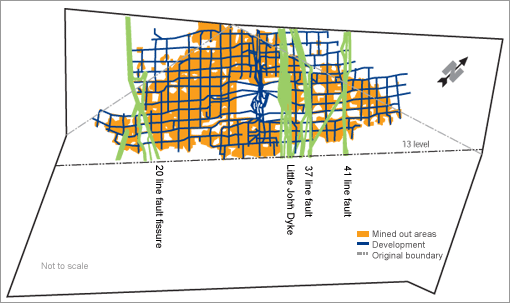
Audited mineral resource and mineral reserve statementThis section reflects the company's audited mineral resources and mineral reserves statement for Merensky and UG2 Reef at 30 June 2004.
* Mill head grade Northam's resources and reserves statement has been compiled by a professional team comprising: |
|||||||||||||||||||||||||||||||||||||||||||||||||||||||||||||||||||||||||||||||||||||||||||||||||||||||||||||||||||||||||||||||||||||||||||||||||||||||||||||||||||||||||||||||||||||||||||||||||||||||||||||||||||||||||||||||||||||||||||||||||||||||||||||||||||||||||||||||||||||||||||||||||||||||||||
| Northam Platinum Limited AR 2004 |
Forward-looking statements | |||||||||||||||||||||||||||||||||||||||||||||||||||||||||||||||||||||||||||||||||||||||||||||||||||||||||||||||||||||||||||||||||||||||||||||||||||||||||||||||||||||||||||||||||||||||||||||||||||||||||||||||||||||||||||||||||||||||||||||||||||||||||||||||||||||||||||||||||||||||||||||||||||||||||||